July 18, 2000
Lightning's Shocking Secrets
By SANDRA BLAKESLEE
| |
|
  The Associated Press, top; Kevin Moloney for The New York Times, bottom;
|
|
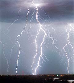
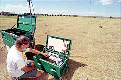
Researchers thought they knew a lot about lightning strikes like this one, in June 1999, near Billings, Montana. But new studies show there is still much to learn. Bottom, Dr. Ron Thomas of the New Mexico School of Mines and Technology monitors signals from 13 lightning detectors in Kansas and Colorado.
|
Related Articles
• The Natural World: Environment
Diagram
•
Nature's Electrical Parade
Forum
• Join a Discussion on The Environment
|
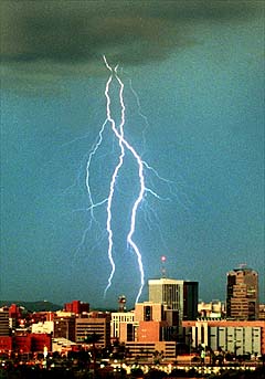
The Associated Press/The Arizona Daily Star/Sergey Shayevich
|
|
Lightning bolts rain down on Tucson in July 1999.
|
|
Zeus were alive and chucking lightning bolts
down from the sky, he would be perched right
over Goodland, Kan. That is where many of the
nation's most violent thunderstorms are
spawned, the kind that drop baseball-size hail,
tornadoes, torrents of rain and furious winds
across the Great Plains states.
So when scientists from nearly a dozen universities and government laboratories recently decided to carry out an advanced study on what
causes lightning and severe weather, they deployed their instruments on the cornfields around
Goodland, hunkered down and waited for Zeus to
rock and roll.
Their eight-week experiment, called the Severe
Thunderstorm Electrification and Precipitation
Study, or Steps, ended on Sunday. Scientists say
that the experiment turned up some stunning
surprises that may force them to revise their
theories of how lightning is produced.
Among the discoveries were many instances of
a rare kind of so-called reverse lightning, in which
electrons shoot upward from the ground to the
cloud, instead of downward as in normal lightning, and new clues about what causes strange
lights called blue jets, red sprites, elves and trolls
that appear in the upper atmosphere above thunderstorms. Sprites, which last long enough to be
seen with the naked eye, happen only above
reverse, or "positive cloud to ground" lightning,
adding to the mystery of both phenomena.
Most important, researchers witnessed several
events within severe storms that seemed to predict when tornadoes would form. For example,
they observed updraft regions in clouds where all
lightning suddenly ceased. Moments later, tornadoes formed in that area. If lightning-free zones
usually precede tornadoes, they said, weather
forecasters might be able to watch for these
"electrical holes" in the clouds and make better
short-term predictions for severe weather, including large hail, heavy rain and tornadoes.
The study was organized because the details of
precipitation, hail and lightning formation within
severe storms are still not completely understood, said Dr. Morris Weisman, a scientist with
the National Center for Atmospheric Research in
Boulder, Colo., who helped coordinate each day's
observations.
"Given similar initial weather conditions, we
don't know why some storms produce downpours
while others contain just as much water vapor but
make very little or no rain," Dr. Weisman said.
With financing from the National Science Foundation, the scientists converged on Goodland
armed with radar, weather balloons, mini-weather stations on wheels, lightning detectors and an airplane that could fly
into the heart of thunderstorms.
They set up this equipment along
the Kansas-Colorado border, where
moist air from the Gulf of Mexico
meets hot, dry air from the Southwest to cook up storms so huge they
can last for days as they move east.
Scientists have thought for years
that they understood basically what
happens inside storm clouds, said
Dr. Donald MacGorman of the National Severe Storms Laboratory in
Norman, Okla. For example, lightning is generated in cold upper layers of air when particles of partly
frozen water and ice crystals collide
inside large clouds. These collisions
generate positive and negative electrical charges the same way that
walking across a carpet on a dry day
can build up static charges and result in a shock when a person touches
a doorknob.
In general, negative charges sink
to the middle or lower parts of the
cloud, while positive charges rise to
upper levels, he said. When air can
no longer insulate these opposite
charges, an avalanche of runaway
electrons initiates a lighting bolt.
Most electrical discharges move
sideways within or between clouds,
but electrical charges can also flow
to the ground in familiar flashes of
lightning.
As for storms, as hot air near the
ground rises into cooler regions, any
moisture in the air condenses into
cloud droplets. Strong updrafts promote the formation of rain, which
can fall and drag air masses back
down to the surface. Storms like this
are short-lived. But if winds are
strong or if there are significant temperature differences and large
amounts of moisture, very large
clouds can evolve into thunderheads
that acquire a vortex of circulating
air. These super cells can produce
tornadoes and other violent weather.
But, as everyone knows, weather is
fickle, Dr. MacGorman said. Some
supercells produce rain, lightning,
hail and tornadoes; some produce no
rain or lightning but pound crops
with large hail; others produce
floods and tornadoes but no lightning
and hail. The reasons for such different outcomes will eventually be
found in the minute physical properties of storm clouds and a better
understanding of chaotic systems,
Dr. MacGorman said.
For the last two months, the Steps
investigators met every morning at
the National Weather Service center
in Goodland and pored over weather
data, looking for the storms.
On good days, when the weather
was bad, the scientists scrambled
into action. Dr. Erik Rasmussen, a
scientist with the Severe Storms
Laboratory, sent out a crew to chase
storms in six Oldsmobiles fitted with
ski racks mounted with weather instruments. These volunteers collected data once a second on winds,
temperature, pressure and humidity
under and near the storm front. Conditions measured on the ground
might help researchers learn what is
happening in the clouds overhead.
For example, on June 29 the volunteers discovered that the air falling
to the ground along the rear flank of
a very large storm had suddenly
turned warm. Minutes later, the
storm spawned quarter-size hail and
a tornado. Still later, measuring other downdrafts at the back of the
same storm, they found that the falling air had suddenly turned cold.
Minutes later it rained and hailed but
no tornado formed.
While this was going on, Charlie
Summers, a pilot employed by the
South Dakota School of Mines and
Technology, took to the skies in a
single-engine airplane designed to fly
through severe weather. Resembling
a 1940's Studebaker with wings, the
craft is armored with 700 pounds of
aluminum coating, a metal grate to
keep hailstones out of its carburetor
and thick acrylic windshields.
Strapped into a four-way harness,
Mr. Summers flew the plane into the
heart of severe storms where he was
buffeted by 50-mile-an-hour vertical
winds, direct lightning strikes, hail
and enough ice to temporarily stall
the engine. Instruments measured
the spectrum of water and ice particles in the clouds, air pressure, temperature and electric fields.
The airplane conked out about a
week before the experiment ended,
said Dr. Andrew Detwiler, an expert
on storm electrification at the South
Dakota School. But the aircraft gathered large amounts of data that will
be compared with information collected on the ground, he said.
While Mr. Summers flew, other
scientists operated special radar stations that could directly measure the
size and shape of water particles in
every cloud. Conventional radar cannot do this. The added information is
expected to shed light on exactly how
lightning is generated.
To study lightning, scientists from
the New Mexico School of Mines and
Technology in Socorro turned on 13
specially built lightning detectors
that were laid out in cornfields under
radar observation. Each detector is
about the size of a small coffee table
and contains a receiver that measures how long it takes for radio signals, which are always produced by
lightning strikes, to arrive, allowing
researchers to calculate the exact
time and location of every lightning
strike in every storm that occurred
during the experiment.
By comparing this detailed picture
of where lightning occurs with radar
images and airplane data on precipitation, it may be possible to learn
more about how lightning is generated, said Dr. Paul Krehbiel, who
helped develop the system.
Preliminary data show that
charge fields -- the layers of positively and negatively charged particles within clouds -- do not fall into
the conventional pattern, Dr. Krehbiel said. They are often upside
down, meaning negative on top and
positive below.
This inverted polarity was also observed by scientists from the National Severe Storms Laboratory, who
released up to four weather balloons
into the belly of each storm. Each
balloon measured temperatures, humidity, pressures, wind directions
and electric fields.
A surprising number of storms
produced the reversed, "positive
cloud-to-ground" lightning that was
thought to be restricted to very large
supercell storms, said Dr. David
Rust, chief of the Mesoscale Research and Applications Division at
the Severe Storms Laboratory.
"We're seeing it in ordinary smaller
storms" along with electrically inverted charge fields, he said.
In a positive-to-ground lightning
strike, positive charges first rush
from the cloud to the ground, creating a lightning channel through
which electrons flow from the
ground back up to the cloud. Such
lightning strikes tend to carry more
charge, last tens of seconds longer
and be less branched than the more
common negative-to-ground lightning. But how this reversal of charge
occurs remains something of a mystery, Dr. Rust said.
"Storms may reverse their polarity all the time, but we just never
knew it," Dr. Krehbiel said. While
scientists on the ground and in the
air over Kansas and Colorado ran
around collecting information on
each storm, other Steps researchers
sat quietly at an observation post
called the Yucca Ridge Field Station
in the foothills of the Rockies near
Fort Collins, Colo.
There, with an unobstructed view
of the Great Plains, researchers
waited for blue jets, red sprites,
elves and trolls -- strange lights that
could be seen with the naked eye or
detected with instruments over the
tops of thunderstorms to the east.
Blue jets are extremely energetic
fields of charged particles that rise
up to 30 miles from the tops of clouds.
After they occur, lightning stops for
several seconds. Red sprites are striated glowing ribbons that rise high
above the jets and reach the ionosphere, lasting for 3 to 10 milliseconds. They happen only over regions
of reverse lightning. Elves are thin,
expanding doughnuts of light found
on the lower edge of the ionosphere.
They tend to occur above sprites
after a lightning pulse. Trolls are
propagating waves of energy that
appear to come back out of cloud
tops and hook up with sprites, but no
one really knows what they are.
"If we were biologists, it would be
like we discovered some new body
parts," said Dr. Walt Lyons, a scientist with FMA Research, a company
that runs Yucca Ridge. Somehow, he
explained, lightning discharges in
the lower atmosphere are having effects in the upper atmosphere.
During the experiment, Dr. Lyons
and his colleagues observed more
than 1,000 red sprites over the dissipating regions of storms where
clouds flattened out and produced a
type of horizontal discharge called
spider lightning or creepy-crawly
lightning. These clouds also produced reverse lightning over which
the sprites were seen.
"We're happy but exhausted," Dr.
Lyons said. It will take time to analyze what happened inside those
clouds, he said, but whatever is going
on may help explain sprites.
Indeed, each researcher said it
will take many years to analyze all
the data collected on the Great
Plains this spring and summer.